Weed Mapping & Biodiversity Mapping
Client: Parramatta City Council 2010

Applied Ecology reviewed biodiversity mapping and updated the Conservation Significance Assessment (CSA) GIS layer for the Parramatta LGA and updated mapping inline with the most up to date vegetation

mapping (left). Applied Ecology undertook fine scale weed mapping(right) at the eight core bushland areas within the LGA and developed a user friendly database to allow Council staff and contractors to replicate the mapping and undertake baseline mapping in other bushland areas in the future.

 Applied Ecology reviewed biodiversity mapping and updated the Conservation Significance Assessment (CSA) GIS layer for the Parramatta LGA and updated mapping inline with the most up to date vegetation
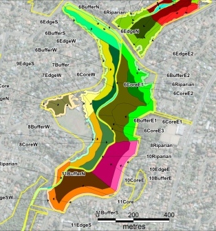 mapping (left). Applied Ecology undertook fine scale weed mapping(right) at the eight core bushland areas within the LGA and developed a user friendly database to allow Council staff and contractors to replicate the mapping and undertake baseline mapping in other bushland areas in the future.