Project: Roadside Vegetation Mapping
Client: Mid-western Regional Council 2010-11

Applied Ecology mapped the roadside vegetation for approximately 2400kms of roads within the Mid-western Regional LGA. Applied Ecology created a A5 map book (right) for use by Council’s operational staff showing locations of EECs, threatened species and other special features located in road reserves. Roadside corridors were ranked based on conservation value and were given a simple colour code with guidelines developed on how to manage each “rank”. A guide to environmental weed and threatened species identification was also provided.The large database (including species inventories, noxious weeds, vegetation condition for
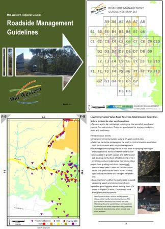
each “section” of road reserve) was integrated into Council’s GIS system. Building upon this new comprehensive layer of information Applied Ecology prioritised roads for rehabilitation works and prepared a large technical report on the vegetation condition of the road reserve network in the LGA.